
Geo Data Collector
Field Data Collection and Mappingthe new 2021 Geo Data Collector by Tech Maven Geospatial
Can be found at https://geodatacollector.techmaven.net
fielddatacollector.xyz http://Geodatacollector.xyz http://geodatacollector.app
This site is old
Ready for any data
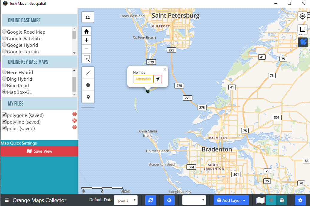
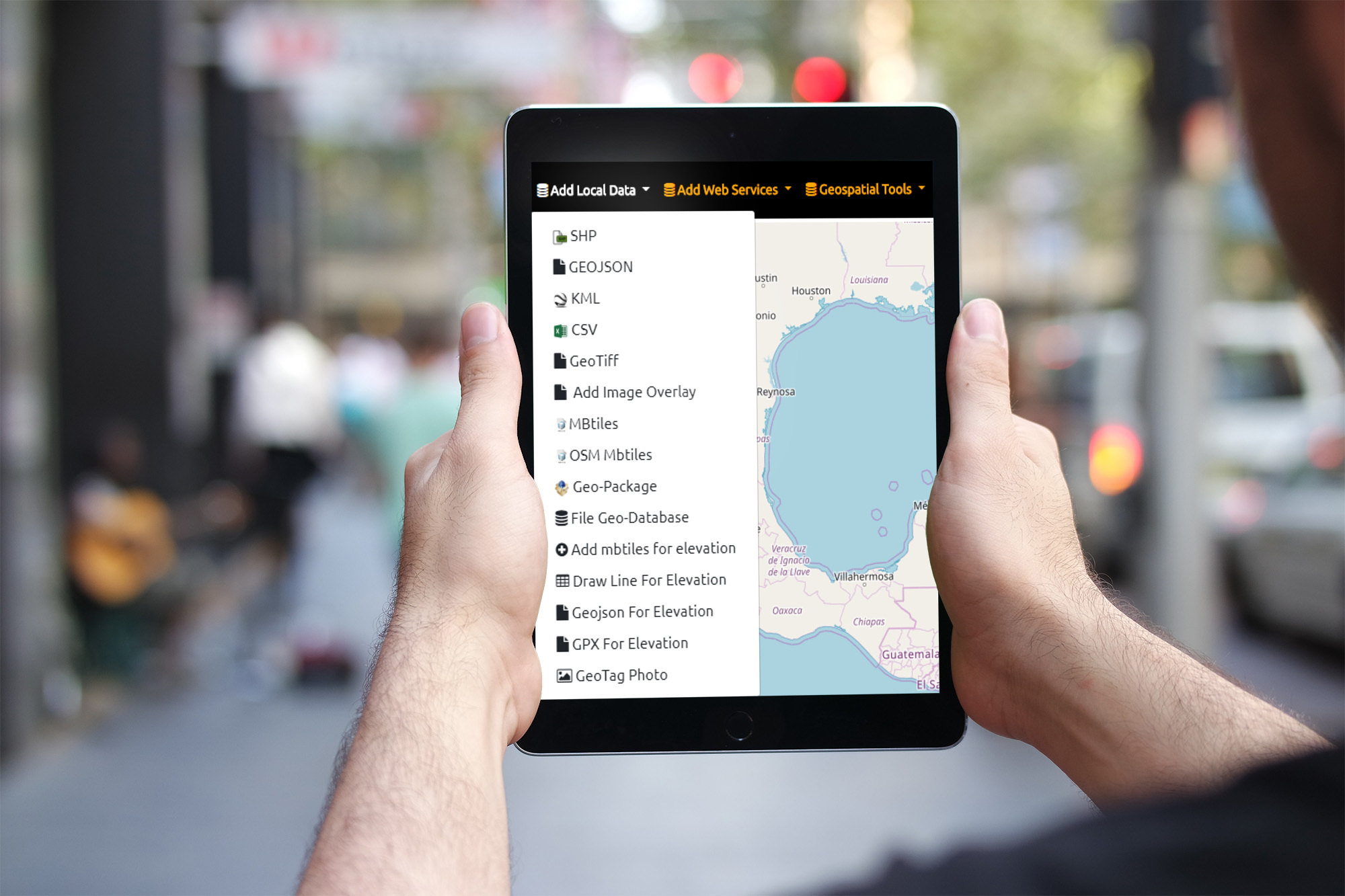
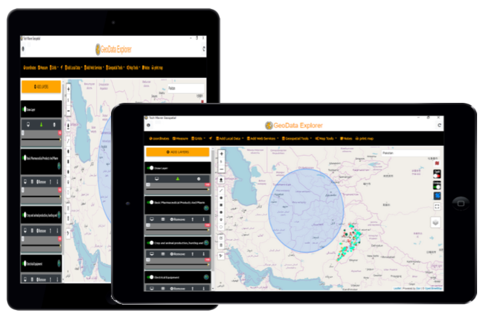
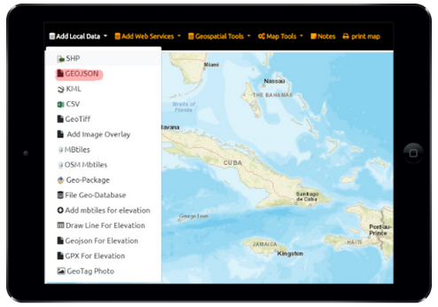
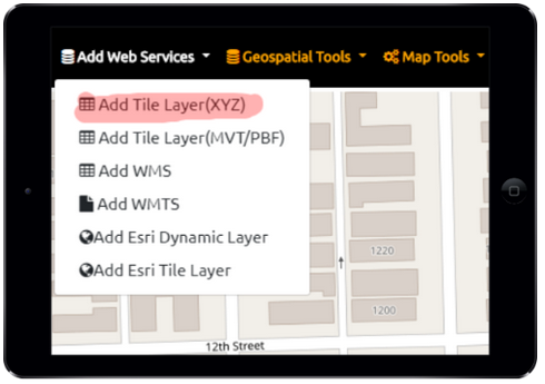
Easily view online Geospatial Data ESRI and OGC Mapping Services, File Based Formats, Draw and Edit Vector Data
GPS & IP Geolocation
Show your position, Show Coordinates Google Place Search and GeoCoding
Affordable
GeoData Explorer is full featured and we have a big roadmap of additional enhancements and new capabilities coming Performance that delivers. Vector Tile basemaps and overlays and transparency/opacity slider for data. Real time savings and enables more access to data
Jam Packed with Useful Features
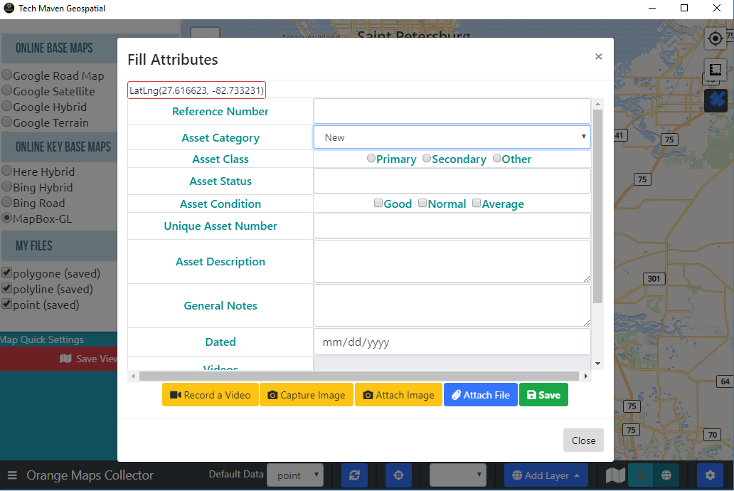
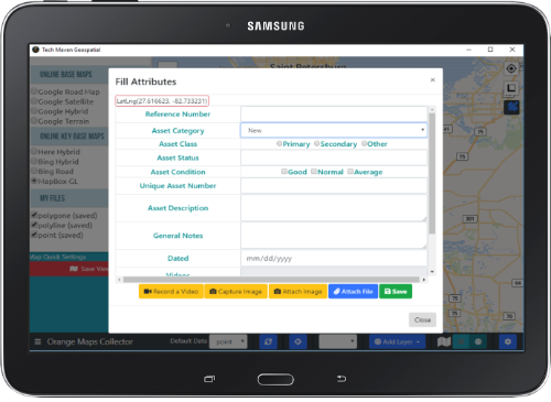
Easy to use ! Easy to collect efficient data with forms with different data types
Attach photos, videos, audio notes, documents to location

Also available for Windows Desktop, Ubuntu Linux and Mac OSX

Amazing Features
Fast and Powerful Data Collection Workflow
We designed Orange Maps Collector after using countless other mobile apps and being frustrated with their limited Geospatial Data format support, offline data collection of points, lines and polygons, no ability attribute table viewing and lack of easy use and sometimes vendor lock-in. So we set out to engineer this product to meet our specifications and realized the benefit it would have to other users.

BaseMap Picker
Select Multiple Basemaps from open source and commercial providers. Google, Bing, ESRI, Stamen, Thunderforest, Open Street Map, HERE, CartoDB, NASA and others.
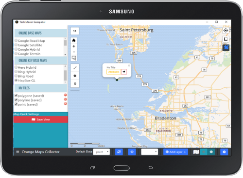
Spatial Bookmarks
Save map extent/location so you can easily come back to an area. Create unlimited spatial bookmarks
View Attribute Table
View attribute table and sort and filter
Map Viewing
Configure different basemaps from our basemap picker or add a new one URL. Display Coordinates (GPS Lat Long, UTM, MGRS, USNG, Maidenhead) and Graticule Lines Our mapping engine is one of the fastest rendering of data you’ll find.
Your Position on Map
Show your position on the map via Geolocation Geolocation feature works with GNSS Receivers (GPS) or WiFi via IP Address. Display routes on the map as well. Display North Compass Arrow Display Coordinates in multiple formats
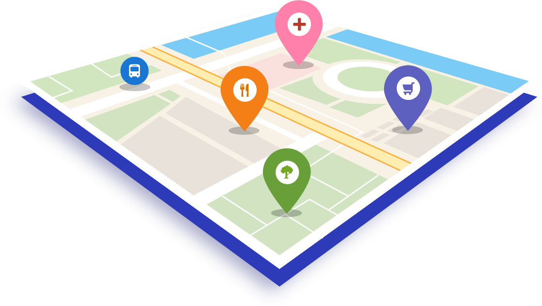
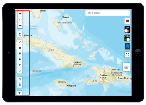
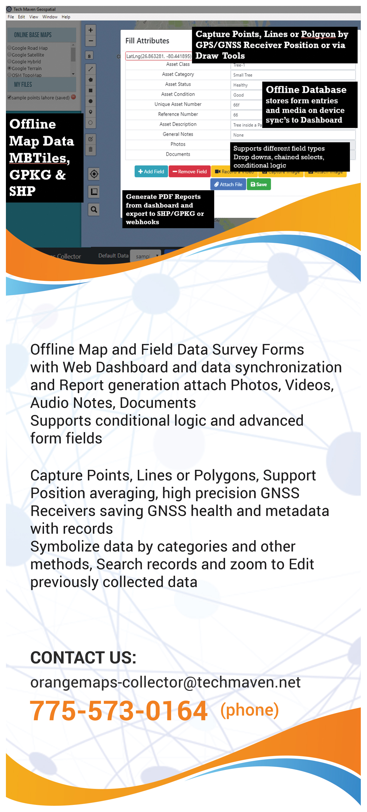
Draw features and assign attributes
Drop a point, Ciricle, Line, Polygon feature on the map and assign unlimited keys and values (attributes) to that location and save as GeoJSON (coming soon save as GPKG). Also, attach media to the location. Full styling control for symbology representation.
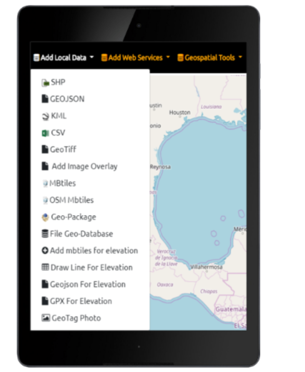
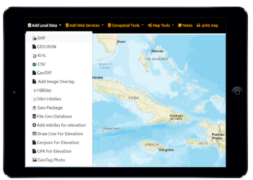
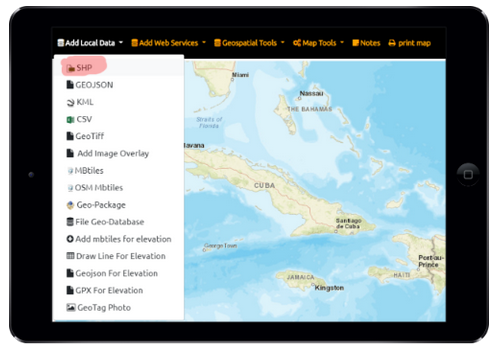
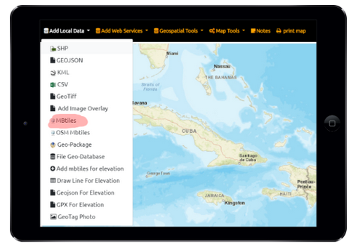
Offline/Disconnected Data
The app supports many formats of offline files and database. (Mbtiles, GeoPackage, Shapefiles, FileGDB, GeoJSON, KML)
Vector Tiles
If you load a GeoJSON file the app will automatically split the file (up to 200mb) into tiles 256×256 pixels and different zoom levels for rapid display and rendering. We also support MapBox Vector Tiles (gzipped PBF) inside MBTiles or via an online XYZ Tile Server. We also support Open Street Map Vector Tiles with different stylesheets
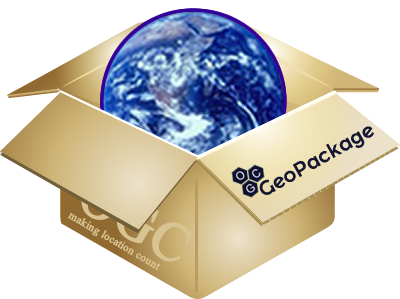
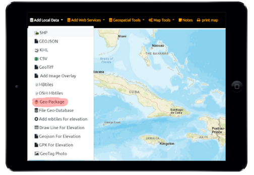
GeoPackage Support
We full support OGC GPKG – GeoPackage SQLite format for offline vector features and raster tiles and elevation tiles
Search loaded Data
Google Services Integration
Full Google Maps and Places Search and Routing/Directions
Labels
Label vector features
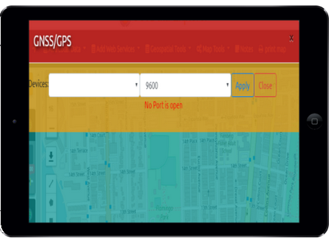
Support for high precision external Bluetooth GPS / GNSS Receivers
Take your survey and mapping and GIS data visualization and data capture to the next level with submeter sub-foot and centimeter (RTK) positions via external Bluetooth, Serial, USB GNSS Receivers (GPS Global Positioning Systems). You can even work with Real-Time Networks (RTN) Continous Operating Reference Receivers and other services for position corrections.
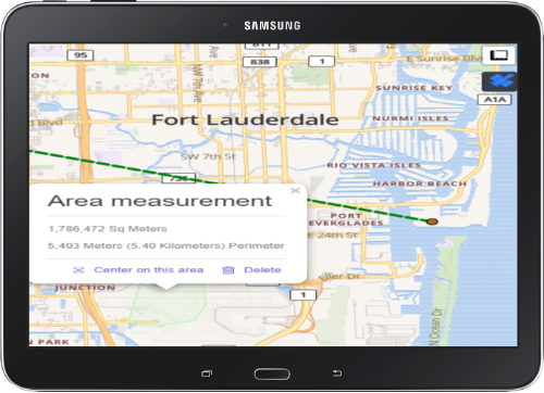
Measure Length and Area
Measure Tools allow you to measure complex linear/lines and area/polygon measurements.
Works Landscape or Portrait Mode
Responsive design that’s flexible to enable you to work landscape or portrait and any screen size/resolution/pixel density Table of Contents Collapses and Top Menu becomes side menu as needed
Catalog/Project Files
JSON Project files for Form Design
Supported Formats:
| Files | Services |
|---|---|
| OGC GPKG - GeoPackage Vector Features | OGC WMTS -TILES -coming soon |
| GPKG Raster Tiles | OGC WMS -coming soon |
| MBTiles Vector Tiles | Raster Tile Server (XYZ/TMS) -coming soon |
| MBTiles Raster Tiles | Vector Tile Server (MVT/PBF) XYZ - coming soon |
| ESRI Shapefile | |
| ESRI FileGDB -Coming Soon | We include basemap picker that includes most popular street map and satellite imagery tile layers when connected to the internet to use. |
| GeoJSON | |
| OSM Vector Tiles MBTILES | |
Perfect for use in an office environment, in a vehicle or in the field you’ve got a fully equipped easy to use GIS that has the capabilities you need.
Feature Tour

JSON Catalog
Label Features
Screen Size and Orientation
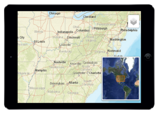
Overview MiniMap
Local Data
Tiling of vector data
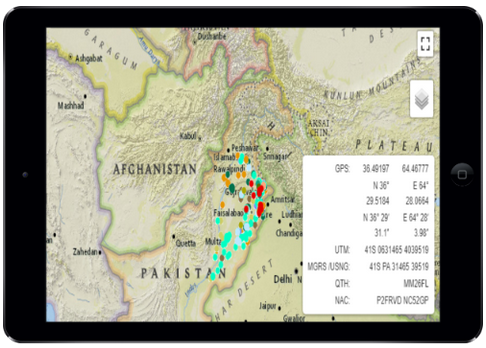
Coordinates
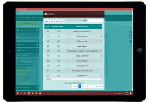
Attribute Table and Export
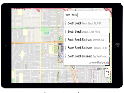
Place Search and Geocoding and Directions
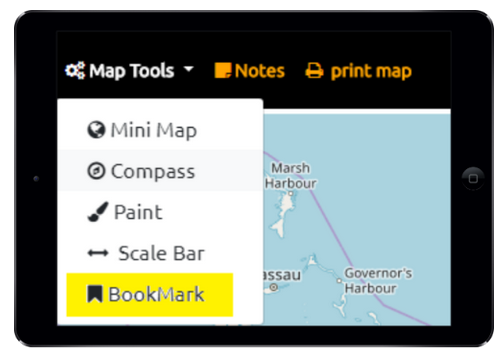
Spatial Bookmarks
Measure Tools
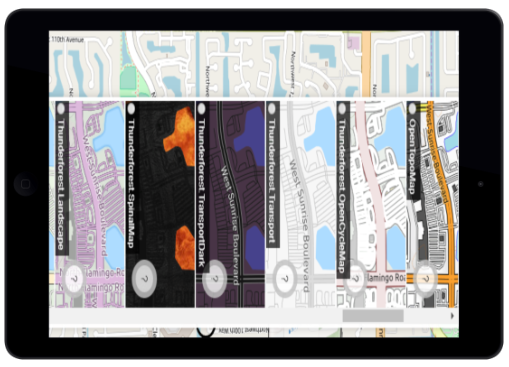
Basemap Picker
OSM Vector Tiles
Raster Tile Server (XYZ or TMS)
ESRI Shapefile
View Offline Raster Tiles (MBTILES/GPKG)
Collect Feature Data
http://orangemapscollector.app http://geodatacollector.xyz
Forms are advanced with ability to have different field types, required fields, validation rules, and app supports collecting Points, Lines and Polygons
Attaching unlimited content (Photos, Videos, Audio notes, Documents, already taken photos/videos) to collected records as well as switching between projects and forms
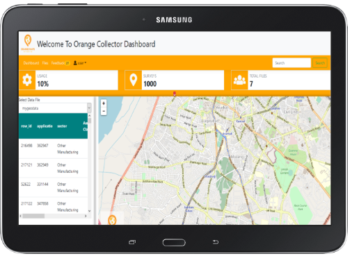
Data is sent to our secure dashboard and database.
Dashboard has advanced form builder and wizard
App also includes form editor for tweaking forms and quickly adding additional fields to capture.
Forms designs can be shared amoung teams.
From their data can be exported in SHP, KML, GeoJSON and in near future additional formats and capabilities like: GeoPackage GPKG, CSV/TSV, SQLite and DWG/DXF and DGN. As well as reproject data to whatever coordinate system users need.
As well as built advanced PDF Reports with media
The App supports navigating back to records and pulling up forms/records by clicking on the map.
GNSS Metadata is stored with the data
Full GIS Editor is included for drawing Points, Lines and Polygons and editing them as well.
Who is Orange Maps Collector app for?
Everyone!
Utilities
Electric, Fiber Optic, Cable, Phone, Water and Wastewater, Natural Gas offline mapping and access to OGC and ESRI Mapping Services make it perfect for utility agencies.
Law Enforcement
Emergency Management
Rescue and Recovery Damage Assessments Coordination and Planning
Real Property and Facility Asset Management
Asset management and mapping
Government Agencies
Any level of Government tons of uses for the app.
Environmental
Monitor environmental conditions, manage resources and assets, perform analysis and print ready maps
Community Health Services
Land Development
Property Appraiser
Commercial Developer
Real Estate Appraiser
Defense and Intelligence
Homeland Security
Agriculture
Perfect for your precision managed Agriculture and large farms.
Use the drawing tool and feature creation to tag information about locations.
View color panchromatic imagery and near infrared from many web services
Ready to get started?
Download the app from your app store or contact us for custom builds and versions. For Windows, we have Windows MSI and EXE builds in addition to the Windows Store APPX
We would love to hear from you
Please feel free to suggest features, enhancements, ideas or data to include
Features Coming Soon:
Tech Maven Geospatial is actively developing and supporting this app and has a large Roadmap of additional features and capabilities will be developed. We also encourage you to send us feedback.
planned future features are:
We make no promise or commitment to have these features available by any time, however, we have a large list of new features and enhancements logged in our application lifecycle management system
- No Dashboard Option and have everything done in the app for clients with restrictions on data being uploaded to the cloud.
- Reproject Vector Data that’s NOT in Geographic WGS84 and possibly support unzipped shp and filegdb
- GL JSON Styling Tool and Load your own vector tile stylesheet
- Integration with Open Street Map (OSM) Overpass API
- Integration with other online services for Points of Interest and Location Data: FourSquare API
- Street Level Photo from Bing, Google and Mappilary
- Recent Satellite Photos from Digital Globe, Planet and ESA Sentinel and Others
- Orthophoto-Aerials, Obliques and other data from NearMap and Geomni
- Options to have richer forms with conditional logic and other powerful features
- GeoFencing with Alerts/Notifications
- Range Rings and other distance calculations
- Social Location Sharing
- Support for OGC WFS-T Web Feature Service Transactional – from dashboard not from app.
- Request an Area of Interest for offline GeoPackage or MBTiles for Raster and Vector Data.
- Support for additional file types and data formats
- GeoServer REST API – for requesting raster imagery to be served or large vector data to be served or converted
- Other Routing and Search services
- Additional Analysis features and functionality like Point in Polygon and intersection
- Additional Export features like OGC GPKG, SHP, SQLite.
- Showing Other references data Layers
and Much Much More…..
We also develop custom apps and solutions and consulting, project management and systems architecture and geospatial data services like map tiling and data conversion. Please contact us regarding your requirements.
Mobile/Desktop GIS Mapping Editing App
If you are looking for an application that’s more centered around full blown GIS with more formats, editing existing data and creating new data and performing analysis. Please check out http://geodataexplorer.world